
CEMETERIES U-W
Information on Vernon County's more than 100 cemeteries and family graveyards.
An ALL-NEW cemetery directory has been published! It includes full names and dates from obituaries and death certificates plus names of parents and spouses for many of the more than 72,000 recorded deaths/burials in Vernon Co. Additionally, a brief source citation for burials is included.
|
Underwood Cemetery (aka Duncan Creek Cemetery) - Henry Township Description: Active; Maintained; Church parish organized 1870; named for J. K. Underwood. Church building burned in the 1970s; suspected arson.. Earliest recorded burial is 1880. Legal: NENE Section 8, Township 37N, Range 33W. Coordinates: 38.015860, -94.574604 Directions: From Stotesbury, MO, 3 3/4 miles north on Hwy V, 1/4 mile west on Caton Road. Cemetery is on the south side of the road. Layout: Listing begins in northeast corner and is by cemetery block and burials within the block. |
|
Vernon County Poor Farm Cemetery - Walker Township Description: Inactive; Unmaintained; Burials were made at the Vernon County Poor Farm located near Walker, MO; however, few are marked. Earliest recorded burial is 1886 and the last known recorded burial was 1934. Legal: SWSW Section 18, Township 30N, Range 36W. Coordinates: 37.892704, -94.282608 Directions: From Walker, 3 miles west on Jayhawker Road, 1/2 mile south on 1900 Road, 1/4 mile east on Katy Track Road. |
|
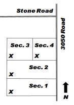
Description: Active; Maintained; Earliest recorded burial is 1859. The town of Virgil City was laid out in 1866. Legal: SW Section 36, Township 35N, Range 29W. Coordinates: 37.760724, -94.082590 Directions: From Nevada, MO, 14 1/2 miles east on U.S. 54, 6 3/4 miles south on Hwy H (3100 Road), 3/4 mile south on 3050 Road. Cemetery is on the west side of the road. Layout: Listing begins in the southwest corner of each section and rows snake. |
|
Wagner Cemetery - see Kaufman Cemetery |
|
Wall Cemetery - see Richland Cemetery |
|
Ward-Vaughan Cemetery - Deerfield Township Description: Inactive; Unmaintained; Family burial area. Daniel Ward settled here in 1869. Earliest recorded burial is 1879. Legal: SWSW Section 13, Township 35N, Range 32W. Directions: From Nevada, MO, 2 miles west on U.S. 54, 1 3/4 miles south on 1200 Road. |
|
Warkins Cemetery (aka Stone Cemetery) - Virgil Township Description: Inactive; Semi-maintained; Earliest known burial is 1847 and the last was 1936. A complete survey of burials in this cemetery is planned in 2010-2011. Legal: SW Section 11, Township 35N, Range 29W. Coordinates: 37.814836, -94.104466 Directions: From Nevada, MO, 13 miles east on U.S. 54, 2 1/2 miles south on 2975 Road, 1/4 mile west on Old Town Road, 1 mile south on 2975 Road to corner with 2913 Road, 1/3 mile west on Panama Road. Cemetery is in the trees about 25 yards north at this corner. (This cemetery was previously incorrectly listed as aka Turner Cemetery.) |
|
Warwick Cemetery - Dover Township Description: Inactive; Unmaintained; Earliest recorded burial is 1880. Area landowner allows his cattle to graze in the cemetery and on the 5-acre church property. Legal: NE Section 29, Township 34N, Range 30W. Coordinates: 37.6742092, -94.2399459 Directions: From U.S. 71 at the Sheldon, MO exit, 3 miles east on Hwy B, 1 mile north on 2125 Road, 3/4 mile east on Yater Road. Church property is on the south side of the road; cemetery is in the grove of trees on the south side of the road. |
|
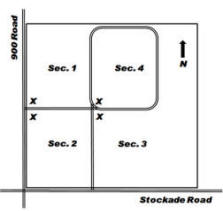
Description: Active; Maintained; Earliest recorded burial is 1872 (a burial removed from a family graveyard to Welborn Cemetery). Legal: SWSW Section 28, Township 35N, Range 32W. Coordinates: 37.782655, -94.476939 Directions: From Nevada, MO, 3 miles west on U.S. 54, 3 miles south on Hwy 43, 2 miles west on Hwy KK (Rebel Road), 1 mile south on 900 Road. Cemetery is on the east side of the road. Layout: Listing begins at the “x” in each section and rows snake. |
|
Westfall Cemetery (aka Garrison Cemetery) - Blue Mound Township Description: Inactive; Unmaintained; Family cemetery. This is the "Westfall place" referred to on page 97 of the 1887 History of Vernon County, MO. Legal: Section 36, Township 38N, Range 30W. Coordinates: 38.0272539, -94.1813351 Directions: From Schell City, MO, 2 1/2 miles west on Hwy C, 1/2 mile north on 2500 Road. Cemetery is located about 1/2 mile west in line with fencerow. |
|
White Cemetery - Richland Township Description: Active; Maintained; Cemetery is named for the Dr. James White family (p. 762, 1887 History of Vernon County, MO). Earliest recorded burial is 1854. Legal: SE Section 28, Township 36N, Range 33W. Coordinates: 37.874413, -94.568413 Directions: From U.S. 54 at Deerfield, MO, 3 miles north on Hwy. H, 3 miles west on Lady Road, 1 mile south on 400 Road and Long Knife Pass. Cemetery is on the west side of the road beside a wooded area. Layout: Listing begins in the southeast corner and rows snake. |
|
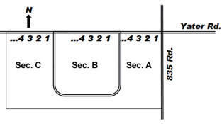
Description: Active; Maintained; Cemetery founded in 1876. A small white chapel stands in the northeast corner of the cemetery. Earliest recorded burial is 1855, a burial removed from Jones Cemetery to Worsley. Legal: NE Section 25, Township 34N, Range 33W. Coordinates: 37.680271, -94.492486 Directions: From the junction of Hwy N and U.S. 43 in Bronaugh, MO, south 1 mile on U.S. 43, west 1 mile on Yater Road. Cemetery is on the south side of the road. Layout: Cemetery is divided by roads into 3 sections. Each row is listed from north to south, beginning from the east side of each section. |
If you have information regarding any Vernon County, Missouri burial site not listed here, please contact the County Coordinator.
This information is provided for use in your personal family history research by the Cedar and Vernon County Missouri Genealogical Society. Do not copy this information and publish elsewhere on the internet, post on other websites, or in blogs without the express written consent of the Vernon County MOGenWeb Coordinator and the Cedar & Vernon County Genealogical Society. Links to web sites that are not part of the USGenWeb Project are provided for your convenience and do not imply any endorsement of the web sites or their content by The USGenWeb Project.
![]()

Missouri State GenWeb Coordinator Asst. State Coordinator
site search engine by freefind
© 2005-2026 Cedar & Vernon County Genealogical Society and
Vernon Co MOGenWeb Coordinator, N. Carroll, County Coordinator email