CEMETERIES M-N
Information on Vernon County's more than 100 cemeteries and family graveyards.
An ALL-NEW cemetery directory has been published! It includes full names and dates from obituaries and death certificates plus names of parents and spouses for many of the more than 72,000 recorded deaths/burials in Vernon Co. Additionally, a brief source citation for burials is included.
|
Maddox Cemetery (aka Batts Cemetery and Dillon Cemetery) - Dover Township Description: Inactive; Unmaintained; Family graveyard originally established on Jesse Maddox property following his death. Legal: SE Section 22, Township 34N, Range 30W. Directions: On private property northwest of the junction of 2425 and Yater Roads. |
|
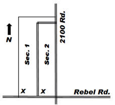
Description: Active; Maintained; Land given by Jackson Fleming in 1883. Earliest recorded burial 1880. Legal: SESE Section 20, Township 35N, Range 30W. Coordinates: 37.790159, -94.256580 Directions: From Nevada, MO, east on Hwy. K in front of Camp Clark area, continuing on Hwy. K 3 miles past corner where road turns east, 1 mile south on 2100 Road to the corner with Rebel Road. Cemetery is on the northwest corner of this junction. Layout: Section listings begin at the X and rows snake. |
|
Mason Cemetery - Osage Township Description: Inactive; Unmaintained; Family burial area no longer exists. It was arbitrarily named Mason because W. H. Mason was the landowner in late 1800s and early 1900s. It is reported that gravestones from this small burial area were thrown into nearby coal strip pits, and a house was built on the site. Legal: NENE Section 28, Township 38N, Range 31W. |
|
Maus Cemetery - Bacon Township Description: Seldom used; Maintained; Earliest recorded burial is 1868. Land deeded to Vernon County by John C. & Margaret Maus in 1906. Legal: SW Section 29, Township 38N, Range 29W. Coordinates: 38.0403089, -94.1452230 Directions: From Schell City, MO, 1/2 mile west on Hwy C, 2 1/4 miles north on Hwy. M. Cemetery is on the west side of the road. |
|
McKill Chapel Cemetery - Harrison Township Description: Active; Maintained; Cemetery in the church yard of McKill Chapel. Earliest recorded burial is 1859. James McKill settled here in 1859, and the Chapel was first built in 1860. In the winter of 1929 the building burned. A nearby Avola church building was purchased, dismantled, and rebuilt on the site; and this is the building that stands today. Legal: SWNW Section 27, Township 34N, Range 33W. Coordinates: 37.674268, -94.545540 Directions: From Bronaugh, MO, 5 miles west on Hwy N, 1/2 mile west on Younger Road. Cemetery is on the north side of the road. Layout: Listing is by row, south to north, beginning on the east side of the cemetery. Each row is designated as a Section. |
|
McMullin Cemetery - Moundville Township Description: Inactive; Unmaintained; Pioneer cemetery. Earliest recorded burial is 1844 and the last recorded burial was 1881. Legal: SE Section 3, Township 34N, Range 32W. Coordinates: 37.735121, -94.421461 Directions: From Moundville, MO, 2 1/4 miles south on Hwy. 43, 1 3/4 miles east on Union Track Road. Cemetery is 1/4 miles north in a grove of trees on private property. |
|
Meek Cemetery - Metz Township Description: Inactive; Unmaintained; The location of this family burial area was somewhere just south of present-day Metz. The Meek family burials were removed to Amos Cemetery more than 100 years ago. |
|
Miller Cemetery - Lake Township Description: Inactive; Semi-maintained; Earliest recorded burial is 1870, and the last recorded burial was 1974. Miller School stood on the north side of the cemetery. Legal: SESE Section 30, Township 36N, Range 32W. Coordinates: 37.872440, -94.494867 Directions: From Deerfield, MO, 2 miles north on Hwy. H, 1 mile east on Militia Road, 1/4 mile north on 800 Road, 1/4 mile west on Long Knife Road (cemetery lane). Layout: Listing begins in the northwest corner and rows snake. |
|
Description: Active; Maintained; Earliest recorded burial is 1886. The Milo community was established in 1881. Legal: NW Section 2, Township 34N, Range 31W. Coordinates: 37.753649, -94.305139 Directions: Located on the south edge of Milo, MO. Layout: Each section begins in the southwest corner and rows snake. |
|
Montevallo Cemetery (aka Academy Cemetery) - Township Description: Seldom used; Semi-maintained; From 1997 Cemetery Directory: "Otis Garber reported that several gravestones (now mislaid) have been plowed up on the site of Old Montevallo (5-34-29)." Earliest recorded burial is 1850. Legal: SW Section 4, Township 34N, Range 29W. Coordinates: 37.728883, -94.12275 Directions: From Montevallo, MO, 1 mile west on Union Track Road near the end of road. Layout: Listing begins in the southwest corner and rows snake. |
|
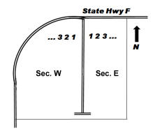
Description: Active; Maintained; James H. Moore, husband of Hester (Caton) Moore, settled here in 1853. Earliest recorded burial is that of Isaac H. Jones (husband of Frances (Caton) Jones) who was murdered in 1849. His burial in Moore Cemetery may have been an re-interment from a family graveyard. Legal: NW Section 16, Township 35N, Range 31S. Coordinates: 37.817124, -94.360789 Directions: From U.S. 54 in Nevada, MO, south on Hwy. BB (S. Ash St.), 1/2 mile past the railroad tracks on the south edge of town. Cemetery is on the east side of the road. Layout: Listing in each section begins at the X and is by row, north to south.
|
|
Mound Cemetery - Walker Township Description: Inactive; Unmaintained; Earliest recorded burial is 1866, and the last recorded burial is 1953. Legal: SESE Section 8, Township 36N, Range 30W. Coordinates: 37.9080914, -94.2499472 Directions: From Walker, MO, 1 mile west on Jayhawker Rd., 3/4 mile north on 2100 Road. At Indigo Pass, the cemetery is on the east side of the road, set back a short distance in the trees. Volunteers Work to Restore Mound Cemetery 2010 newspaper story. |
|
Description: Active; Maintained; Earliest recorded burial is 1868. Legal: NE Section 5, Township 34N, Range 32W. Coordinates: 37.764133, -94.460524 Directions: From Hwy 43 in Moundville, MO, 1/2 mile west on Hwy. F. Cemetery is on the south side of the road. Layout: Section 1 is the east side; Section 2 is the west side. Rows are numbered from the center drive toward the outside of each section, all rows listed north to south. |
|
Mt. Calvary Cemetery - Center Township
Legal: NE Section 5, Township 35N, Range 31W. Coordinates: 37.848680, -94.371228 Directions: In Nevada, MO, north on North Olive Street past Bryan Middle School to Garfield Street; turn west into cemetery. Layout: All sections begin in the southwest corner and rows snake. Section 1 is within the hedge. Section 2 begins outside the hedge at the south end of the west row. |
|
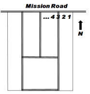
Description: Active; Maintained; Earliest recorded burial is 1857. Legal: NESE Section 34, Township 36N, Range 29W. Coordinates: 37.851001, -94.108372 Directions: From Nevada, MO, 12 miles east on U.S. 54 past Dederick, 1/8 mile south on 2850 Road, 1/2 mile east on Mission Road. Layout: Each row begins at the north end and is listed as a Section. |
|
Description: Active; Maintained; Mt. Vernon Church organized about 1861. Cemetery organized 1884. Land given by Mr. & Mrs. B. Snodgrass, Emma Langley and Ruby Hutchison. Earliest recorded burial is 1871. Legal: NENE Section 20, Township 36N, Range 29W. Coordinates: 37.888123, -94.141728 Directions: From Nevada, MO, 10 miles east on U.S. 54, 2 1/8 miles north on 2700 Road. Church and cemetery are at the corner of 2700 and Katy Track Roads. Layout: Listing begins in the southwest corner of each section and rows snake. |
|
Nevada State Hospital #3 Cemetery - Washington Township Description: Inactive; Maintained; Cemetery for burial of deceased patients during the time the Nevada State Hospital #3 was in operation. Earliest recorded burial is 1884 and last recorded burial was 1962. Some duplicate entries below indicate the listing from the plat map. Legal: SW Section 29, Township 36N, Range 31W. Coordinates: 37.872922, -94.367312 Directions: From U.S. 54 in Nevada, MO, 2 1/2 miles north on Hwy W (North Ash Street), 1/2 mile west on Logan Road. Cemetery is on the south side of road (on the west side of Callaway Cemetery). Layout: Cemetery diagram is available at the Nevada Habilitation Office, 2323 N Ash St, Nevada, MO where a gate key can be checked out for visiting the cemetery during regular business hours. |
|
Newsom Cemetery - Dover Township Description: Inactive; Unmaintained; Small family burial area. Legal: Township 34N, Range 30W. Directions: From Milo, MO, 3 miles east and 3 miles south. |
|
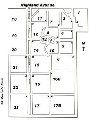
Description: Active; Maintained; Formally founded Oct. 12, 1911 by William A. Newton. Newton’s wife was the first burial. A stone chapel dedicated May 29, 1932 has been completely removed. Earliest recorded burial is 1865, a removal from another cemetery. Legal: NESW Section 32, Township 36N, Range 31W. Coordinates: 37.858270, -94.361840 Directions: From U.S. 54 in Nevada, MO, north on Hwy. W (North Ash St.) to Highland Ave., west 1/4 mile. Cemetery is on the south side of the road. Layout: The listing for each section begins at the "x" and north-south rows snake. Section 55 (Potter's Field) is located near the far southwest fence of the cemetery. |
|
Nielsen Cemetery - Clear Creek Township Description: Seldom used; Maintained; Family burials on the family farm. Legal: SWNE Section 23, Township 36N, Range 29W. Directions: From U.S. 54 at Dederick, 2 1/2 miles north on Hwy AA, 1 mile east on Katy Track Road, 1/8 mile north on 2900 Road, 1/2 mile east on Justin Road, 1/2 mile south on 2950 Road. Cemetery is on the east side of the road. |
 Marvin Chapel Cemetery - Badger Township
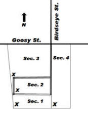 Milo Cemetery - Drywood Township
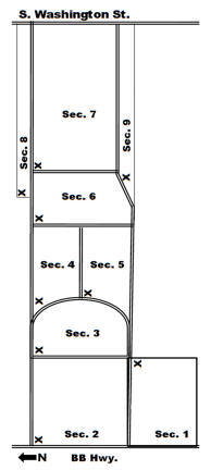
 Moundville Cemetery - Moundville Township
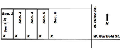
 Mt. Pleasant Cemetery (aka Blakey Cemetery and Hargrove Cemetery) -
Clear Creek Township
Mt. Pleasant Cemetery (aka Blakey Cemetery and Hargrove Cemetery) -
Clear Creek Township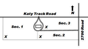
If you have information regarding any Vernon County, Missouri burial site not listed here, please contact the County Coordinator.
This information is provided for use in your personal family history research by the Cedar and Vernon County Missouri Genealogical Society. Do not copy this information and publish elsewhere on the internet, post on other websites, or in blogs without the express written consent of the Vernon County MOGenWeb Coordinator and the Cedar & Vernon County Genealogical Society. Links to web sites that are not part of the USGenWeb Project are provided for your convenience and do not imply any endorsement of the web sites or their content by The USGenWeb Project.
![]()

Missouri State GenWeb Coordinator Asst. State Coordinator
site search engine by freefind
© 2005-2026 Cedar & Vernon County Genealogical Society and
Vernon Co MOGenWeb Coordinator, N. Carroll, County Coordinator email