CEMETERIES C-D
Information on Vernon County's more than 100 cemeteries and family graveyards.
An ALL-NEW cemetery directory has been published! It includes full names and dates from obituaries and death certificates plus names of parents and spouses for many of the more than 72,000 recorded deaths/burials in Vernon Co. Additionally, a brief source citation for burials is included.
|
Callaway Cemetery - Washington Township Description: Seldom used; Maintained; Dr. Larkin H. Callaway settled here in 1855. The earliest recorded burial is 1856 and the last is 1988. Legal: SE Section 29, Township 36N, Range 31W. Coordinates: 37.872846, -94.366207 Directions: From U.S. 54 in Nevada, MO, about 2 miles north on Hwy W/North Ash St. and turn left (curve) onto Logan Road for about 1/2 mile. Cemetery is on the south side of the road and on the east side of the Nevada State Hospital #3 Cemetery. Layout: Listing begins in the northeast corner and rows snake. |
|
Camp Clark Prisoner of War Cemetery - Center Township Description: Inactive; Maintained; During World War II, Camp Clark was used as a prisoner of war facility for German and Italian prisoners, and deceased prisoners were buried there. Deceased prisoners from Camp Crowder prisoner of war facility were transported to Camp Clark for burial. Following the war, all remains were repatriated. Out of respect, a few white wooden crosses were placed in recent years to mark and preserve the location of the burial area. Only deaths found in the Missouri death certificates are listed here. Directions: Camp Clark is located southeast of Nevada on Hwy K. |
|
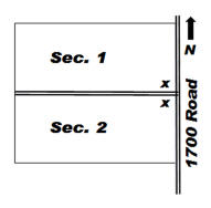
Description: Active; Maintained; The earliest recorded burial is 1879. Carbon Center was an active coal mining community in the late 1800s and early 1900s, and nothing remains of the town except a few scattered homes, coal strip pits, and the cemetery. Legal: NENE Section 27, Township 38N, Range 31W. Coordinates: 38.049848, -94.317389 Directions: From U.S. 71 1/2 mile south of the Vernon-Bates County line, 2 miles east on Hwy. TT, 1/3 mile north on Roads 1688 and 1700. The cemetery is on the west side of the road. Layout: Listings in both sections begin at the "x" at the entrance and rows snake. |
|
Caton Burying Ground - Washington Township Description: Inactive; Unmaintained; The Caton family graveyard was located northeast of the commemorative stone that now stands at the former homesite of Noah Caton. The Caton cabin was the location where the first Vernon County court was held for the purpose of organizing county government. The Caton pioneer family burial area was destroyed in the 1940s by the then land owner. The below list are some of the several burials that were in this family graveyard. Legal: NE Section 20, Township 36N, Range 31W. Directions: From U.S. 54 in Nevada, MO, about 2 miles north on Hwy W/North Ash St. and continue about 1 1/2 miles further north on 1525 and 1475 Roads. Cemetery was several yards from the east side of the road. |
|
Clark Cemetery - Henry Township Description: Inactive; Semi-maintained; The earliest recorded burial is 1861 and the last is 1960. This was the cemetery of the Christian Church of Pryor Creek, which no longer exists. Legal: NE Section 36, Township 38N, Range 33W. Coordinates: 38.040419, -94.507248 Directions: From Metz, MO, 3 1/2 miles west on Hwy MM, 2 3/4 miles north on 650 Road. About 1/2 way down the hill, the entrance gate and lane to the cemetery are on the east side of the road. A new cemetery entrance gate has recently been installed. |
|
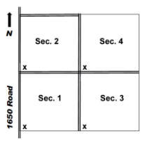
Description: Active; Maintained; Earliest burial is 1870. The Cemetery Association was formed 1888. Legal: NWSE Section 34, Township 36N, Range 31W. Coordinates: 37.854534, -94.335533 Directions: This cemetery is located off the east side of Nevada, MO. From Nevada, 1 mile east on U.S. 54, 1/2 mile north on 1700 Road, 1/2 mile west on Mission Road, 1/4 mile south on 1650 Road. The cemetery is on the east side of the road. Layout: Listing in each section begins at the "x" and rows snake. |
|
Coleman Cemetery (originally Baker Cemetery) - Richland Township Description: Inactive; Maintained; Established in 1863, this is an inactive, maintained cemetery; and no additional burials are permitted. The earliest recorded burial is that of Captain Augustus Baker who was murdered on May 6, 1863 and buried on his farm. (See 1887 History of Vernon County, MO, p. 311 and 754). The cemetery is now commonly known as Coleman Cemetery after Baker’s son-in-law, John Coleman, who lived on the family farm for some time. The last recorded burial was in 1949 except that a burial was made in 1998. A cemetery board has been reestablished and yearly maintenance provided. Legal: NWSW Section 30, Township 36N, Range 33W. Coordinates: 37.878275, -94.612112 Directions: From Deerfield, MO, 3 miles north on Hwy H, 6 miles west on Lady Road, 1/2 mile south on 100 Road. Follow the old train bed east (private property) about 1/4 mile, and the cemetery sets on the north side of the train bed near Shiloh Creek. |
|
Confederate Mass Grave - Montevallo Township Description: Inactive; Semi-maintained; A party of 13 men from the northern part of the county, living in the vicinity of Balltown, were on their way to join Confederate forces on Horse Creek when they encountered Union forces. Five of the young men were killed and buried in a mass grave near where they fell. An inscribed tomb was later erected over the grave. (See 1887 History of Vernon County, MO, p. 308.) Legal: SENW Section 11, Township 34N, Range 29W. Coordinates: 37.42.337, 094.05.017 |
|
Cox Cemetery - Richland Township Description: Inactive; Unmaintained; Family graveyard. The earliest recorded burial is 1869 and the last burial is 1906, except one made in 1931. Legal: SE Section 33, Township 36N, Range 33W. Coordinates: 37.861277, -94.570731 Directions: From Deerfield, MO, 4 miles west on U.S. 54, 1 mile north on 300 Road, 3/4 mile east on Nebo Hill Road. The cemetery is on private property about 1/2 mile north of the road. |
|
Creek Cemetery - see Olive Branch Cemetery |
|
Davis Cemetery (aka Shanghai Cemetery) - Drywood Township Description: Inactive; Maintained; Family burial area. Earliest recorded burial is 1870 and the last burial is 1937. Legal: NENE Section 31, Township 34N, Range 31W. Coordinates: 37.662505, -94.365027 Directions: From the Sheldon, MO exit on U.S. 71, 3 1/2 miles west on Hwy N, 3/4 mile south on 1525 Road. Cemetery is on the west side of the road enclosed in a wrought iron fence. |
|
Davis Cemetery - see Stevens Cemetery |
|
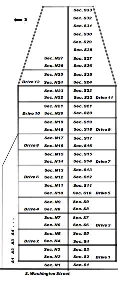
Description: Active; Maintained; Earliest recorded burial is 1841. Several burials from the old Hopkins Graveyard on the northwest edge of Nevada were removed to Deepwood cemetery in Nov. 1887. Legal: SE Section 9, Township 35N, Range 31W. Coordinates: 37.829870, -94.355639 Directions: From U.S. 54 in Nevada, MO, south at the traffic light onto Washington Ave and proceed south for 7 blocks. The cemetery is on the east side of the road. Layout: Each row is listed as a Section (North, South, Addition). North and South Sections begin at the center drive and go out. Sections in the North Addition are numbered beginning at the west side.
|
|
Description: Active; Maintained; Earliest recorded burial is 1840. Abram Redfield, the original settler, was buried here in 1862. The town was not regularly laid out until 1871. Legal: NE Section 12, Township 35N, Range 33W. Coordinates: 37.837488, -94.513063 Directions: On U.S. 54 at Deerfield, MO, south on Hwy. H for 200 yards and west on Osage Nation Road (Old 54 Hwy) for about 200 yards. The cemetery is on the south side of the road. Layout: Listing for each section begins in the northwest corner. Listed by rows, each row beginning from the north end. |
|
Dillon Cemetery - see Maddox Cemetery |
|
Dover Cemetery - Dover Township Description: Inactive; Unmaintained; Cemetery was regularly laid out in 1866 by an association of citizens, the site to be used "forever" as a cemetery. Interments were made here as early as in 1850. The earliest recorded burial now known is 1874. Legal: NENW Section 21, Township 34N, Range 30W. Coordinates: 37.41.231, 094.13.821 Directions: On U.S. 71 3 miles north of Sheldon, MO, turn east onto Hwy. DD and proceed about 5 1/4 miles. The cemetery is about 150 yards south of the road. |
|
Duncan Creek Cemetery - see Underwood Cemetery |
|
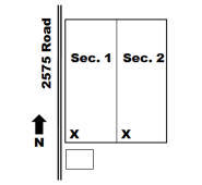
Description: Active; Maintained; Earliest recorded burials are 1863 Civil War. Legal: NWNE Section 25, Township 34N, Range 30W. Coordinates: 37.670387,-94.171736 Directions: From U.S. 71 at the Sheldon, MO exit, 7 miles east on Hwy B (Zebulon Rd.), 1 mile north on Hwy DD (2525 Road), 1/2 mile east on Yater Road, 1/4 mile south on 2575 Road. The cemetery is on the east side of the road next to the old Dunnegan Grove Church. Layout: The cemetery has two sections; listings begin in the southwest corner of both. |
|
Durham Cemetery - Lake Township Description: Inactive; Unmaintained; This single burial location has been plowed over. A small broken stone found in the area bears the date 1870, the death date of William Durham who owned the land 1866-1870. He was buried beside the old Durham School. After the old school house burned in 1967, a new building was built across the fencerow to the west where it stands today. The well at the original school site remains to mark the location of the pioneer Durham School, and numerous long-time residents recall seeing the Durham gravestone on the north side of the old school building. Legal: NENE Section 28, Township 36N, Range 32W. Coordinates: 37.882229, -94.457896 Directions: From U.S. 71 at Deerfield, MO, 3 miles north on Hwy H, 2 3/4 miles east on Lady Road. The Durham Community Building is on the south side of the road and on the west side of the fencerow from the original Durham School and gravesite location. |
 Deepwood Cemetery -
Center Township
Deepwood Cemetery -
Center Township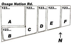
A - B C - D E - H J - L M - N O - T U - W
If you have information regarding any Vernon County, Missouri burial site not listed here, please contact the County Coordinator.
This information is provided for use in your personal family history research by the Cedar and Vernon County Missouri Genealogical Society. Do not copy this information and publish elsewhere on the internet, post on other websites, or in blogs without the express written consent of the Vernon County MOGenWeb Coordinator and the Cedar & Vernon County Genealogical Society. Links to web sites that are not part of the USGenWeb Project are provided for your convenience and do not imply any endorsement of the web sites or their content by The USGenWeb Project.
![]()

Missouri State GenWeb Coordinator Asst. State Coordinator
site search engine by freefind
© 2005-2026 Cedar & Vernon County Genealogical Society and
Vernon Co MOGenWeb Coordinator, N. Carroll, County Coordinator email