
CEMETERIES J-L
Information on Vernon County's more than 100 cemeteries and family graveyards.
An ALL-NEW cemetery directory has been published! It includes full names and dates from obituaries and death certificates plus names of parents and spouses for many of the more than 72,000 recorded deaths/burials in Vernon Co. Additionally, a brief source citation for burials is included.
|
Jewell Cemetery (originally Ely Cemetery; aka Beard Cemetery) - Deerfield Township Description: Seldom used; Maintained; Earliest recorded burial is 1868, and the last recorded burial is 1986. Cemetery association organized in 1880. Legal: NE Section 23, Township 35N, Range 32W. Coordinates: 37.809538, -94.429368 Directions: From Nevada, MO, 3 miles west on U.S. 54; 2 miles south on Hwy. 43; 1/2 mile east on Quail Road. Cemetery is on the south side of the road. |
|
Johnson Cemetery - Washington Township Description: Inactive; Unmaintained; Information on burials in this graveyard was found in 1892-1897 newspapers. The exact location in Washington Township has not been found. See Holman Cemetery. |
|
Jones Cemetery - Center Township Description: Inactive; Unmaintained; Many graves are marked with river rock and the engraving is no longer readable. Earliest recorded burial is 1859, and the last burials were in 1911. Legal: NE Section 31, Township 35N, Range 31W. Coordinates: 37.772809, -94.386163 Directions: From Nevada, MO, 4 miles south on Hwy. BB; 1/2 mile west on Summers Road; 1/3 mile north on 1400 Road. Cemetery is on the west side of the road in the woods. |
|
Kaufman Cemetery (aka Wagner Cemetery) - Henry Township Description: Seldom used; Maintained; Land was given by Roy Johnson, Sr., in 1887. Earliest recorded burial is 1870, and the last was 1986. Legal: SW Section 28, Township 37N, Range 33W. Coordinates: 37.964958, -94.577125 Directions: From Stotesbury, MO, 1/2 mile west on Hwy D, 1/2 mile south on 300 Road. Cemetery is on the east side of the road. |
|
Kelsay Cemetery - see Sand Hill Cemetery |
|
Kendall Cemetery - Harrison Township Description: Inactive; Unmaintained; Family graveyard. Earliest recorded burial is 1862. Cemetery was destroyed with construction of house and pond in the area. Legal: SE Section 28, Township 34N, Range 33W. Directions: From Bronaugh, MO, 5 miles west on Hwy N; 1/2 mile west on Younger Road. Cemetery is on the south side of the road, on a dirt road in the timber. |
|
Klein Cemetery (previously Stein Cemetery) - Washington Township Description: Inactive; Unmaintained; Family graveyard. Legal: NE Section 5, Township 36N, Range 31W. Directions: From Nevada, MO, 6 miles north on U.S. 71, east on Gray Road, about 1 mile south on 1463 Road. Cemetery is east of the road on private property. |
|
Description: Active; Maintained; Deeded for public burial ground by James Lawrence family in 1858. Earliest recorded burial is 1858. Historical plaque installed Oct. 2008 to memorialize the raid of John Brown and his gang on three northwest Vernon County farms on the night of Dec. 20, 1858, in which the murder of an elderly respected pioneer settler, David Cruise, took place. Eleven slaves and several thousands of dollars in property were pillaged and taken back to Kansas. This Missouri raid was a trial run for Brown's more infamous raid on Harper's Ferry a year later. Legal: SE Section 5, Township 37N, Range 33W. Coordinates: 38.023230, -94.574776 Directions: From Stotesbury, MO, north 4 miles on Hwy V. Cemetery is on a hill on the west side of the road. Layout: Sections are by west to east rows, designated by letters, and beginning in the northwest corner. |
|
Leeper Cemetery - Blue Mound Township Description: Inactive; Unmaintained; Family burial plot. The earliest recorded burial is 1844. Information previously furnished by Maxine Berry. Legal: NE Section 24, Township 37N, Range 30W. Directions: 3/4 mile southwest of Fair Haven, MO. |
|
Lefler Cemetery - Bacon Township Description: Active; Maintained; Levi Lefler settled here in 1882. Earliest recorded burial is 1863. Legal: SE Section 34, Township 37N, Range 29W. Coordinates: 37.931057, -94.108769 Directions: From Nevada, MO, 11 miles east on U.S. 54 to Dederick, 5 miles north on Hwy AA (2800 Road), 3/4 mile east on Halley Road. Cemetery is on the north side of the road. Layout: Listing begins in the southwest corner, and rows snake. |
|
Ligon Cemetery - Montevallo Township Description: Inactive; Unmaintained; Family burial area. Legal: NENE Section 29, Township 34N, Range 29W. Coordinates: 37.67425, -94.07375 Directions: From Sheldon, MO, 10 miles east on Hwy B, 1 1/2 miles north on 2925 Road, 1 1/2 miles east on Whitworth Road, 1/2 mile south on 3062 Road, continuing south 1/2 mile on 3075 Road, 1/4 mile east on Yater Road. Cemetery is about 1/4 mile south in timber. |
|
Lipe Cemetery - see Grimsley Cemetery |
|
Living Faith Mennonite Cemetery - Walker Township Description: Active; Maintained; Earliest recorded burial is 1986. Legal: NWNW Section 13, Township 36N, Range 30W. Coordinates: 37.901475, -94.191499 Directions: From Walker, MO, 2 1/2 miles east on Hwy EE. Cemetery is located at the Living Faith Church. |
|
Little Osage Burying Ground - see Balltown Cemetery |
|
Lockhart Cemetery - Deerfield Township Description: Inactive; Unmaintained; Pioneer burial on the late-1860s farm of John Lockhart. Legal: Section 10, Township 35N, Range 32W. Directions: From Nevada, MO, 4 miles west on U.S. 54 and 1/2 mile south. |
|
Logan #1 Cemetery (originally Profitt Cemetery) - Coal Township Description: Inactive; Unmaintained; Earliest recorded burial is 1859, and the last is 1929. Legal: NE Section 34, Township 35N, Range 33W. Coordinates: 37.7786526, -94.5563457 Directions: From Moundville, MO, 2 miles north on Hwy 43, 6 miles west on Hwy. KK (Rebel Road), 1 mile south on 500 Road, 1/4 mile west on Stockade Road. Cemetery is about 1/2 mile south on private property on the south side of a pond. |
|
Logan #2 Cemetery - Badger Township Description: Inactive; Unmaintained; From 1979 Cemetery Directory: Cemetery located but all headstones are now moved; was unable to find out what happened to any markers at this time. The majority of names were said to be LOGAN and BRANDT. Legal: SE Section 35, Township 36N, Range 30W. Directions: From Nevada, MO, 9 miles east on U.S. 54, 1 mile south on 2400 Road. |
|
Longacre Cemetery - see Bicket Cemetery |
|
Lovell Cemetery - Badger Township Description: Inactive; Unmaintained; Family burial area on private property. Legal: NWSE Section 18, Township 35N, Range 30W. Coordinates: 37.811700, -94.281986 Directions: Located in a grove of trees at the crest of a hill in a pasture. Closest road is within Camp Clark. |
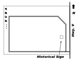 Lawrence Cemetery -
Henry Township
Lawrence Cemetery -
Henry Township
If you have information regarding any Vernon County, Missouri burial site not listed here, please contact the County Coordinator.
This information is provided for use in your personal family history research by the Cedar and Vernon County Missouri Genealogical Society. Do not copy this information and publish elsewhere on the internet, post on other websites, or in blogs without the express written consent of the Vernon County MOGenWeb Coordinator and the Cedar & Vernon County Genealogical Society. Links to web sites that are not part of the USGenWeb Project are provided for your convenience and do not imply any endorsement of the web sites or their content by The USGenWeb Project.
![]()

Missouri State GenWeb Coordinator Asst. State Coordinator
site search engine by freefind
© 2005-2026 Cedar & Vernon County Genealogical Society and
Vernon Co MOGenWeb Coordinator, N. Carroll, County Coordinator email