
CEMETERIES E-H
Information on Vernon County's more than 100 cemeteries and family graveyards.
An ALL-NEW cemetery directory has been published! It includes full names and dates from obituaries and death certificates plus names of parents and spouses for many of the more than 72,000 recorded deaths/burials in Vernon Co. Additionally, a brief source citation for burials is included.
|
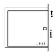
Description: Active; Maintained; Earliest recorded burial is 1873. Legal: SE Section 28, Township 37, Range 33W. Coordinates: 37.959764, -94.559176 Directions: From U.S. 54 at Deerfield, MO, 8 miles north on Hwy H to Richards, 3 miles north on Hwy Z, about 100 yards north on Hwy V. Cemetery is on the west side of the road. Layout: Listing is by double row, south to north, beginning in the southeast corner. |
|
Ellis Cemetery - (AKA Hunter Cemetery) Washington Township Description: Inactive; Maintained; Earliest recorded burial is 1847 and the last burial is 1917. William and Willis Ellis were pioneer settlers of the township. Legal: SESE Section 17, Township 36N, Range 31W. Coordinates: 37.895760, -94.371239 Directions: From U.S. 54 in Nevada, MO, travel north on Hwy W (N. Ash St.) for 2 1/2 miles; at curve, continue north on paved 1525 Road, winding around to the corner of Jesse Road and 1450 Road. Turn south on private drive for 1/2 mile; cemetery is in pasture (private property) south of home. Layout: Listing begins in the northwest corner and is by row. Each row is called a Section. |
|
Ellis Railroad Burial - Deerfield Township Description: Inactive; Maintained; An unidentified woman about 20 years old was found dead at this location April 21, 1877, apparently murdered. Following an inquest, she was buried where she had been found, on the railroad right-of-way. For years, railroad section crews kept up the grave, and local people still maintain and decorate it annually. Legal: SW Section 11, Township 35N, Range 32W. Coordinates: 37.824447, -94.434518 Directions: From Nevada, MO, 3 miles west on U.S. 54; south 1 mile on Hwy 43, 1/2 mile east on Panama Road. Burial is in a small mowed area on the north side of the road near the railroad bed. |
|
Ely Cemetery - see Jewell Cemetery |
|
Emery Cemetery - Deerfield Township Description: Inactive; Unmaintained; Family graveyard established in 1873 on land set aside by Aaron Emery. Earliest recorded burial is 1873 and the last recorded burial is 1885. Legal: SENE Section 25, Township 35N, Range 32W. Coordinates: 37.788802, -94.409391 Directions: From Nevada, MO, 3 miles west on U.S. 54, 2 miles south on U.S. 43, 2 miles east on Quail Road, 1 1/4 miles south on 1300 Road. Cemetery is located on private property about 1/4 mile west of the road. Follow the fence on the south side of the railroad bed west to the pond and go straight south to the bank of Ingram Creek. |
|
Eureka Cemetery - Harrison Township Description: Inactive; Unmaintained; Pioneer cemetery has been completely destroyed and stones removed. Legal: NENW Section 18, Township 34N, Range 33W. Directions: From Nevada, MO, 11 miles west on U.S. 54, 8 miles south on Hwy T (270 Road), cross Hwy F and continue 1 mile south on gravel road, 1 mile west on Waldo Road. Cemetery was located on the south side of the road in the old Eureka School yard. |
|
Fairview Cemetery - see Click Cemetery |
|
Fields Cemetery - see Turley Cemetery |
|
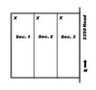
Description: Active; Maintained; Earliest recorded burial is 1844. Legal: SESE Section 35, Township 38N, Range 30W. Coordinates: 38.022461, -94.198462 Directions: From Schell City, MO, 4 miles west on Hwy M, 1/8 mile north on 2350 Road. Cemetery is on the west side of the road. Layout: Listing in each section begins in the northwest corner, and rows snake. |
|
Frazier Cemetery - Dover Township Description: Inactive; Unmaintained; From the 1979 Cemetery Directory: Previously, Mrs. Walter Thompson and others reported a Frazier Cemetery was located on land owned by Ingles Ferry in the north central portion of Section 5. A neighbor reported that there are three graves marked with inscribed sandstone markers. It is presumed these are graves of the Frazier family, early settlers of the township (see 1887 History of Vernon County, MO page 845). Legal: Section 5, Township 34N, Range 30W. |
|
Garrison Cemetery - see Westfall Cemetery |
|
Gill Cemetery - Harrison Township Description: Inactive; Semi-maintained; Earliest recorded burial is 1874, and the last two recorded burials were 1934 and 1976. Legal: NENW Section 32, Township 34N, Range 33W. Coordinates: 37.667380, -94.576042 Directions: From Bronaugh, MO, 4 1/2 miles west on Hwy N, 1 3/4 miles west on Yater Road, 1 mile south on 400 Road (road has a jog with other road names), 1/8 mile west on Zebulon Road. Cemetery is on the south side of the road. Layout: Listing begins in the northeast corner and rows snake. |
|
Description: Active; Maintained; Organized in 1879; land obtained from the Schell City town company. The 1887 History of Vernon Co., Missouri, page 716 reads: "The site of the original town cemetery is now a cultivated garden in the northwestern portion of town." It is reported that marked graves in the original cemetery were removed to the new cemetery. However, cemetery records reflect very few or no burials for the years between 1871 and 1879. Legal: NWNE Section 5, Township 37N, Range 29W. Coordinates: 38.018725, -94.140666 Directions: From Schell City, MO, 1 mile west on Hwy C/M. Cemetery is on the south side of the road. Layout: Listing is by row, north to south, beginning at the east side. Rows are designated as Sections. |
|
Description: Active; Maintained; Land bought from Mr. & Mrs. William Rutherford by H. J. McCullough, G. W. Steincross, and A. J. Jarvis and donated for a cemetery in 1888. Earliest recorded burial is 1885. Legal: SENW Section 19, Township 37N, Range 29W. Coordinates: 37.968950, -94.163979 Directions: From Nevada, MO, 5 1/2 miles east on U.S. 54, 10 1/2 miles north on Hwy C, 1/2 mile east on Elias Road. Cemetery is located on the north side of the road. Layout: Listing is by row, south to north, beginning on the southwest side. Rows are designated as Sections. |
|
Grimsley Cemetery (aka Lipe Cemetery) - Montevallo Township Description: Inactive; Unmaintained; Small family burial area. John B. Grimsley settled here in 1867. Earliest recorded burial is 1869, and the last recorded burial was 1884. Legal: NW Section 4, Township 34N, Range 29W. Coordinates: 37.44.991, 094.07.387 Directions: From Montevallo, MO, 1 mile west on Hwy E; 1 mile north on 2825 Road. Cemetery on private property. |
|
Hackberry Cemetery - Deerfield Township Description: Seldom used; Maintained; Established in 1880. Land given by Albert Truskett. Earliest recorded burial is 1867. Legal: NENW Section 29, Township 35N, Range 32W. Coordinates: 37.793652, -94.486065 Directions: From Nevada, MO, 3 miles west on U.S. 54, 3 miles south on Hwy 43, 2 1/2 miles west on Hwy KK (Rebel Road), 1/8 mile south on 850 Road. Layout: Listing begins in the southwest corner. |
|
Halley's Bluff Cemetery - Blue Mound Township Description: Inactive; Maintained; Earliest recorded burial is 1945. Legal: SE Section 27, Township 38N, Range 30W. Coordinates: 38.02.212, 094.12.670 Directions: From Schell City, MO, 4 3/4 miles west on Hwy C (Bailey Road); 1 mile north on 2275 Road. |
|
Hargrove Cemetery - see Mt. Pleasant Cemetery |
|
Harwood Cemetery - see Green Mound Cemetery |
|
Heavisides Cemetery (property Reynolds Cemetery) - Harrison Township Description: Active; Maintained; Earliest recorded burial is 1862. Cemetery Articles of Incorporation filed Dec. 5, 1896. Legal: NE Section 8, Township 34N, Range 33W. Coordinates: 37.720383, -94.572287 Directions: From Moundville, MO, west on Hwy F about 5 1/2 miles to Hwy FF; 3 1/2 miles west on Hwy FF; 1/2 mile south on 375 Road. Layout: Listing begins in the northwest corner and rows snake. |
|
Hereford Cemetery - Coal or Richland Township Description: Inactive; Unmaintained; Pioneer burial area located somewhere near Clayton in western Vernon Co. Only known recorded burial was 1893. |
|
Holman Cemetery - Washington Township Description: Inactive; Unmaintained; Holman stones were recently found in the area, hence the name Holman Cemetery. The exact location of the graveyard and its proper name have not yet been determined. The general area is west of U.S. 71 in Section 9. This could possibly be Johnson Cemetery. |
|
Hunter Cemetery - see Ellis Cemetery |
 Flat Rock Cemetery - Blue Mound Township
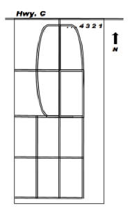 Green Lawn Cemetery (aka Green Lawn Cemetery) - Bacon Township
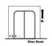
If you have information regarding any Vernon County, Missouri burial site not listed here, please contact the County Coordinator.
This information is provided for use in your personal family history research by the Cedar and Vernon County Missouri Genealogical Society. Do not copy this information and publish elsewhere on the internet, post on other websites, or in blogs without the express written consent of the Vernon County MOGenWeb Coordinator and the Cedar & Vernon County Genealogical Society. Links to web sites that are not part of the USGenWeb Project are provided for your convenience and do not imply any endorsement of the web sites or their content by The USGenWeb Project.
![]()

Missouri State GenWeb Coordinator Asst. State Coordinator
site search engine by freefind
© 2005-2026 Cedar & Vernon County Genealogical Society and
Vernon Co MOGenWeb Coordinator, N. Carroll, County Coordinator email