
CEMETERIES O-T
Information on Vernon County's more than 100 cemeteries and family graveyards.
An ALL-NEW cemetery directory has been published! It includes full names and dates from obituaries and death certificates plus names of parents and spouses for many of the more than 72,000 recorded deaths/burials in Vernon Co. Additionally, a brief source citation for burials is included.
|
Oak Grove Cemetery (aka Baker Cemetery) - Drywood Township (This cemetery is correctly Baker Cemetery.) |
|
Old Order Mennonite Cemetery - Metz Township Description: Active; Maintained; Cemetery established near the Old Order Mennonite Church (formerly the Bethel Baptist Church building). Legal: SENE Section 26, Township 38N, Range 32W. Coordinates: 38.048302, -94.408.575 Directions: From Metz,, MO, 1 3/4 miles east on Dalton Road, 3 1/2 miles north on 1200 Road. Cemetery is on the northwest corner at the junction of Albert and 1200 Roads. |
|
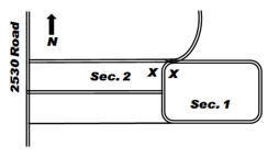
Description: Active; Maintained; Earliest recorded burial is 1861. Legal: SW Section 1, Township 34N, Range 30W. Coordinates: 37.731489, -94.178882 Directions: From Nevada, MO, about 5 1/2 miles south on U.S. 71 to Hwy E, 7 1/4 miles east on Hwy E, 1 3/4 miles south on 2525 Road. Cemetery is on the east side of the road. Layout: Listing begins at the “x” for each section. |
|
Osage Valley Cemetery - see Pryor Creek Cemetery |
|
Other Cemetery Description: This listing contains burials that are located other than in Vernon County, Missouri, and burials in Vernon County for which the specific cemetery is not known. The cemetery, city, county and state are listed, if known. |
|
Prince Cemetery - Coal Township Description: Inactive; Unmaintained; Small community burial area. Legal: SWSW Section 13, Township 35N, Range 33W. Coordinates: 37.813530, -94.526582 Directions: South of Deerfield about 2 miles on 600 Road. Burial area is about 1/4 mile east on private property. |
|
Profitt Cemetery - see Logan #1 Cemetery |
|
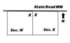
Description: Active; Maintained; Earliest recorded burial is 1870. Legal: NENW Section 17, Township 37N, Range 32W. Coordinates: 37.999012, -94.477497 Directions: From Metz, MO, 1 mile west on State Rd WW and continue 3/4 mile further west on State Road MM. Cemetery is on the south side of the road. Layout: Listing is by row from the center alley. Sections are East and West, with rows numbered. |
|
Reynolds Cemetery - see Heavisides Cemetery |
|
Rhea Cemetery - Metz Township Description: Inactive; Unmaintained; Earliest recorded burial is 1847 and the last is 1930. Legal: SWNW Section 17, Township 37N, Range 32W. Coordinates: 37.992333, -94.481885 Directions: From Metz, MO, 1 mile west on State Rd WW and continue 1 mile further west on State Road MM, 1/2 mile south on 800 Road, 1/4 mile east on private drive. Cemetery is in trees east of where the drive turns north. |
|
Richards Cemetery - see Richland Cemetery |
|
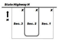
Description: Active; Maintained; Organized early 1880s; incorporated 1884. Land obtained from Capt. Frank Koontz. Earliest recorded burial is 1878. Legal: NE Section 14, Township 36N, Range 33W. Coordinates: 37.913614, -94.533234 Directions: From U.S. 54 at Deerfield, MO, 6 1/2 miles north on Hwy H. Cemetery is on the south side of the road. Layout: Each section begins in the northeast corner and north-south rows snake. |
|
Rinehart Cemetery - Metz Township Description: Active; Maintained; Cemetery at the Rinehart Christian Church. Earliest recorded burial is 1876. Legal: NE Section 32, Township 37N, Range 32W. Coordinates: 37.949942, -94.468281 Directions: From Nevada, MO, 6 miles north on U.S. 71, 5 1/2 miles west on Hwy D (Grange Road), 1/2 mile south on 900 Road. Cemetery is on the west side of the road, across from the Rinehart Christian Church. Layout: Listing begins in the northeast corner and rows snake. |
|
Robinson Cemetery - see Ball Cemetery |
|
Rosewood Cemetery - Drywood Township Description: Inactive; Unmaintained; It has been reported that most of the stones in this burial area were removed from the area by a previous landowner. Legal: SWNE Section 18, Township 34N, Range 31W. Coordinates: 37.701318, -94.370708 Directions: From U.S. 43 1/2 mile north of Bronaugh, MO, 4 1/2 miles east on Hwy N. Cemetery is 1/8 mile north of the road on private property. |
|
Ryan Cemetery - Metz Township Description: Inactive; Unmaintained; Family burial area. Earliest recorded burial is 1872. Legal: NE Section 30, Township 38N, Range 32W. Coordinates: 38.053228, -994.488945 Directions: From Metz, MO, west and north on Hwy WW for 5 miles, 1 1/2 miles west on Aaron Road. Gravestones are located 1/4 mile south on private property. |
|
Sand Hill Cemetery (aka Kelsay and Turner Cemetery) - Virgil Township Description: Inactive; Unmaintained; Earliest recorded burial is 1858; last recorded burial was 1909. Legal: NW Section 30, Township 35N, Range 29W. Directions: From Nevada, MO, east on Hwy. K to 2500 Road. South 1 1/4 mile on 2500 Road. Cemetery is on the east side of the road on private property. |
|
Sandstone Cemetery - Badger Township Description: Seldom used; Maintained; Cemetery established in 1873. Earliest recorded burial is 1871. Legal: NESE Section 35, Township 35N, Range 30W. Coordinates: 37.7667064, -94.2196673 Directions: From Nevada, MO, 5 miles south on U.S. 71, 5 miles east on Hwy E, 1/2 mile north on 2300 Road. Cemetery is on the east side of the road. Layout: Listing begins in the northwest corner. |
|
Schell City Cemetery - see Green Lawn Cemetery |
|
Shanghai Cemetery - see Davis Cemetery |
|
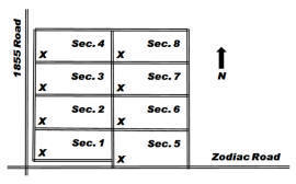
Description: Active; Maintained; Earliest recorded burial is 1869. The town of Sheldon dates from 1881. Legal: SW Section 35, Township 34N, Range 31W. Coordinates: 37.647496, -94.304903 Directions: From the Sheldon, MO, exit on U.S. 71, east on Hwy B (Zebulon Road) about 1/4 mile, 1 mile south on 1855 Road, east on Zodiac. Cemetery is on the north side of the road. Layout: Listings in each section begin in the southwest corner and rows snake. |
|
Shields Cemetery - Montevallo Township Description: Inactive; Unmaintained; Family burial area. Fence installed with inscription “6 May 1984, fence donated from donations received at the family reunion 1983. Billy J. Evans.” Legal: NESE Section 23, Township 34N, Range 29W. Coordinates: 37.67425, -94.07375 Directions: From Sheldon, MO, 10 miles east on Hwy B, 1 1/2 miles north on 2925 Road, 1 4/5 miles east on Whitworth Road. Cemetery is located about 1/8 mile south in timber. |
|
Snodgrass Cemetery - see Mt. Vernon Cemetery |
|
Stein Cemetery - see Klein Cemetery |
|
Stepp Cemetery - Badger Township Description: Inactive; Unmaintained; Earliest recorded burial is 1860. Joseph Stepp was a pioneer settler of Vernon Co. Volunteers plan to begin cemetery cleanup and restoration in 2010. Legal: SWSE Section 4, Township 35N, Range 30W. Coordinates: 37.836776, -94.241710 Directions: From the junction U.S. 71 and Business U.S. 71 in Nevada, MO, east on Hwy. K about 1/2 mile and continue east on Old Town Road for 1 mile, 1/2 mile north on 1900 Road, 2 miles east on Noah Road, south on 2100 Road, 3/4 mile east on Northern Road. Cemetery is on the south side of the road in a grove of trees. |
|
Stevens Cemetery (aka Davis Cemetery) - Harrison Township Description: Seldom used; Maintained; Small cemetery of only 14 different surnames. The earliest recorded burial is 1872. Legal: SE Section 3, Township 34N, Range 33W. Coordinates: 37.739558, -94.533824 Directions: From Moundville, MO, 4 1/2 miles west on Hwy F, 1 1/2 miles west on Ulysses Road (to the end of the road). Cemetery is on the north side of the road. Layout: Listing begins in the southeast corner and is by row; each row is designated a Section. |
|
Stone Cemetery - see Warkins Cemetery |
|
Summers Cemetery - Metz Township Description: Inactive; Maintained; Cemetery cleanup began winter 2009. The first white settlers in Vernon Co., the Summers brothers and their families, are buried in this pioneer cemetery. Legal: SWSE Section 14, Township 37N, Range 32W. Coordinates: 37.984063, -94.420023 Directions: From Metz, MO, 1 1/2 mile east on Dalton Road, 3/4 mile south on 1150 Road, private property (the last 1/4 mile is dirt road and sometimes impassable). |
|
Teel Cemetery - Unknown Township Description: Inactive; Unmaintained; The location of this family burial area is presently unknown. |
|
Temple Cemetery - Lake Township Description: Inactive; Unmaintained; Earliest recorded burial is 1870, and the last recorded burial is 1917. Legal: NE Section 26, Township 36N, Range 32W. Coordinates: 37.8814268, -94.4224517 Directions: From U.S. 54 in Deerfield, MO, 3 miles north on Hwy H, 4 3/5 miles east on Lady Road. Cemetery is on the south side of the road; stones are about 50 yards from the road in the woods. |
|
Terrel Cemetery - Blue Mound Township Description: Inactive; Unmaintained; Family burial area with one known burial. Legal: S Central Section 28, Township 37N, Range 30W. Directions: From Walker, MO, 2 1/2 miles north on Hwy C, 1 1/2 miles north on Hwy OO. Cemetery on private property. |
|
Tolson Cemetery (also Toalson Cemetery) - Dover Township Description: Active; Maintained; Earliest burial is thought to be that of Abraham Jobe, 1861. Legal: SW Section 21, Township 34N, Range 30W. Coordinates: 37.679456, -94.233749 Directions: From Sheldon, MO, exit on U.S. 71, 3 miles east on Hwy B, 1 mile north on 2125 Road, 1 mile east on Yater Road, 1/3 mile north on 2225 Road, 1/4 mile east on cemetery lane. Cemetery is at the end of the lane. Layout: Listing begins in the southwest corner and rows snake. |
|
Turley Cemetery (aka Fields Cemetery) - Henry Township Description: Inactive; Unmaintained; Earliest recorded burial is 1868. Legal: NE Section 34, Township 37N, Range 33W. Coordinates: 37.9522589, -94.5452326 Directions: From U.S. 71 6 miles north of Nevada, MO, 10 miles west on Hwy D. Cemetery is on private property about 1/2 mile south of road and in timber near the crest of the hill. |
|
Turner Cemetery - see Sand Hill Cemetery (This cemetery was previously incorrectly listed as Warkins Cemetery.) |
If you have information regarding any Vernon County, Missouri burial site not listed here, please contact the County Coordinator.
This information is provided for use in your personal family history research by the Cedar and Vernon County Missouri Genealogical Society. Do not copy this information and publish elsewhere on the internet, post on other websites, or in blogs without the express written consent of the Vernon County MOGenWeb Coordinator and the Cedar & Vernon County Genealogical Society. Links to web sites that are not part of the USGenWeb Project are provided for your convenience and do not imply any endorsement of the web sites or their content by The USGenWeb Project.
![]()

Missouri State GenWeb Coordinator Asst. State Coordinator
site search engine by freefind
© 2005-2026 Cedar & Vernon County Genealogical Society and
Vernon Co MOGenWeb Coordinator, N. Carroll, County Coordinator email